

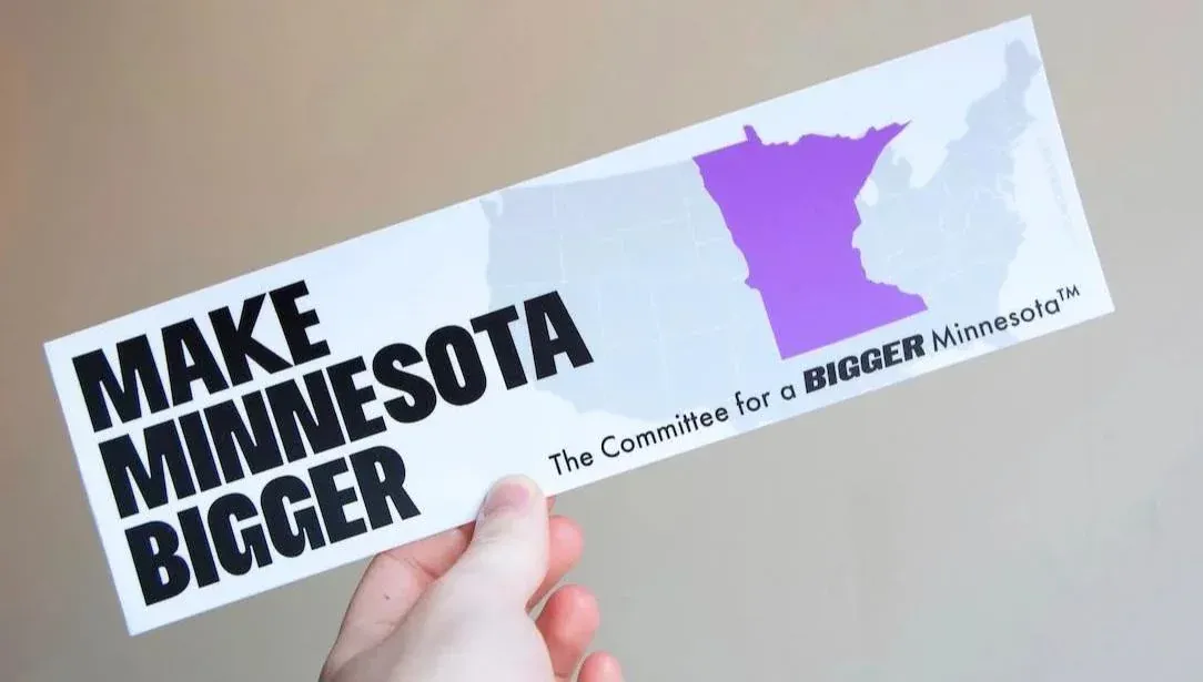
Where is Gotham and Springfield
Pert’ much.
Eh, close enough.
I was gonna say.
Want to see the map of Asia that most US-Americans could draw.
Basically China, India and Japan with a Vietnam somewhere but they don’t want to talk about it.
Hey now, North Korea is in there somewhere by Vietnam, too.
No american knows India is in Asia. They think Asia is just south east Asia. I’ll allow that for the Brits tho
Why would you allow that for brits? India was a British colony you know?
?? By allow it I mean I’d understand if the shown map was what a Brit thought Asia was
Nobody’s asking anyone to draw a map from memory. They’re asking a news channel to put in the 5 seconds of googling it takes to procure an accurate map.
I was going to be all proud and then I realized you said “most”…
Oof.
============================== Russia ============================== Iran | China | Japan ============================== Saudi Arabia | India | Vietnam ==============================I’d add in Mongolia and call Myanmar Burma at first but otherwise, yeah.
Hmmm. Given a map I could do china, japan, vietnam, korea, taiwan and I think tibet, but if you asked me to draw a map I definitely wouldn’t get the placement of korea and vietnam and tibet right. India I could get too, if we’re going for continental asia. Maybe Kazakhstan? I’d guess that I’d probably be more accurate than the average american, but not great.
I would hope you’d find Russia on a map too
Hmmm, never heard of it
You mean eastern Ukraine?
That’s cool and all, but if we’re directly correlating this, then I think it would be more like you drawing out the provinces in China or India.
China I could maybe get Manchuria, Inner Mongolia, Tibet kinda right, I’d try to get Guangdong, Szechuan and Xi’an, the rest I’m screwed (Heibei maybe? Guangzhou? Idfk). Perhaps I’d be better to stick to the 3 kingdoms.
India I’m much more screwed. Kashmir, North India, South India, Delhi, something called Gujurat maybe, Bengal, Pashtun?, Bombay, Goa? Throw the Ganges somewhere in there in the North and East…a desert in the west, North and South Mountains that are not called mountains? Now that I’m thinking about it, I’d probably draw it out as Kashmir, that big strip that hugs the Ganges and Himalayas where Delhi is, and Texas.
This isn’t me being like “look how much I know!”, it’s the exact opposite hahaha
china, japan, vietnam, korea, taiwan and I think tibet,
So … China, then
#freetibet
#nobordersnonations
Tibet should be independent after Republic of China liberates the mainland of terrorists
The Republic of China also claims Tibet.
That’s irrelevant to “Tibet should be independent”
I do want to hear the difference between #FreeTibet and #FreeCaledonia and all other separatist movements. Hell even, #FreetheAmericaFromTheEuropeans
China and India are about right, Japan’s south of Taiwan, Vietnam is labeled South Korea, all the other islands are “you get the idea” squiggles. The rest is a wash. Anyone who remembers the Philippines is in the Armed Forces. Anyone who can place Thailand encrypts their hard drive.
All of central Asia is “Afghanistan?”.
China, India, Vietnam, Russia, Australia.
Probably Japan.
Maybe Tibet. Maybe Pakistan. Not sure about Afghanistan.
Australia would include Papua, Vietnam would get the rest of Southeast Asia, Indonesia, Malaysia, Philippines, Myanmar, you name it. It was a big war, must’ve been a big place. Who even knows what countries are there? It’s like the Balkans of Asia. India would look mostly the same, a bit bigger.
If Pakistan is included it probably would include Afghanistan as Afganistan is definitely in the Middle East and not in Asia, but Pakistan (If they remember it, with the weird border ritual video that became so popular) is so closely associated with India that there’s a chance it’s included. Maybe India gets Pakistan while Pakistan ends up around Iran.
China gets a lot of Kazakhstan, all of Mongolia and some of Russia. It’s possible some random chunk of western China gets the name Tibet. Russia stays mostly the same, whether they or China get the Korean peninsula is a toss-up. There’s a decent chance the Russian border just gets moved way north.
Depending on who you ask, Korea might also be included as it’s own thing. But it might end up in a weird place like Vladivostok, the Kola peninsula, or some place in China.
There’s a decent chance they know most of the main islands of Japan and it ends up looking a little cursed but mostly in the right place. I’m thinking it would either stop short of Hokkaido or seize Sakhalin.
Central Asia doesn’t exist.
i wanna see the map of the USA that most USAians can draw
A bit like a map on how Europe is perceived by Americans, where whole Germany is Bavaria.
As if Americans have any idea what Bavaria is. And if they could even name one city in Germany it certainly wouldn’t be anything in the south, it’d be Hamburg, because hamburgers lol
Isn’t heidelberg super famous because of Elvis?
Not anymore.
I feel like Berlin would be more famous, with it being the capital and the Berlin wall.
Don’t forget the Oktoberfest in Munich.
as an American, i was going to go berlin, munich, and then “that part in the south everyone seems to hate for being hicks”
I know I don’t live in Texas because we still have electricity running here. Florida checks out though!
I love how jarring the border of what would normally be Nevada is compared to the rest of the borders on this map lmao. Also love how Michigan is split in half between NY and Texas
Everything is bigger in Texas. Including cartography.
If you’ve ever driven from east Texas through El Paso, it definitely feels this big.
That not how it looks?
This ad brought to you by the bipartisan Canadiasexicans and Texasexicans super pac union for the succession of Sexico
Sexico sounds like what Zapp Brannigan would say is his hometown
Or force Kif to say.
Brannigan: Kif! Chart a course to my home state of Sexico! Kif: long sigh
I don’t get this though. Maps are free online. You don’t even have to guess anymore.
Exactly. Maps are free. Joke maps are also free. So instead of paying money, and somebody taking that money and assuring you this is the right thing. You get a free map, that might be a joke, but you don’t know it’s a joke cuz you don’t know the map. And we get some funnies
Where do they take maps from? 9gag? I mean, maps.google.com is free. It can’t be any easier.
I mean 9gag stands for 9 Good American Guys right? What better place to get your accurate American maps from?
Google images most likely
Yes, I’m sure using Google content on your commercial news channel is simple as can be.
You don’t have to use their content, but you can double-check that your map is correct, mister sarcasm.
Have you ever tried drawing a map from memory? It’s interesting, what you do and don’t remember and why. That’s why this is funny - what’s salient to the other person and what’s not. No American would want Florida to be bigger, for instance.
Come on guys, Ohio is above Texas
This is what those “state vs state battle royale” fantasy war simulators look like after a couple rounds
If you had to condense it for a videogame, this would cover most bases.
GTA 7: Great Plains, Cacti, and Propane
Los Santos, Liberty City, Vice City.
And the big empty bit in the middle to hide the loading.
That’s just Red Dead.
It certainly feels that way sometimes.
Politically. Yeah that’s about right


